Hot on the tracks of feral animals in the Top End
They destroy wetlands and creeks, cause declines in water quality, spread diseases that could be passed on to livestock, and destroy infrastructure like roads and fences which are so important in remote areas.
Past attempts at controlling these introduced pests have had limited success, but recent advances in digital technologies might be about to change that.
A team of scientists and Indigenous Rangers have been connecting feral animals up to the internet.
New technology developed by CSIRO with James Cook University and Indigenous ranger groups in Arnhem Land and Cape York is bringing invasive species monitoring into the data age and allowing for real-time monitoring of the animals.
The GPS tracker designed by Data61. Photo: Chris McKay, CSIRO
Telecommunication infrastructure then receives the signals from the trackers and sensors to deliver information about the feral animals and the habitats they frequent.
The GPS trackers, developed by CSIRO’s Data61 researchers, are made at a fraction of the cost of commercially available alternatives.
This has opened up the prospect of conducting large-scale tracking projects that have not been economically feasible before.
Using a low-power and long-range communication system, called LoRa, the GPS trackers and the environmental sensors upload their data to CSIRO’s Senaps cloud service in near real-time, as the animals are roaming around.
The local expertise of Indigenous rangers has been instrumental in the effectiveness of the technology.
Initial tests of the equipment at the Djelk Indigenous protected area in east Arnhem Land showed that the use of digital technology in remote areas presents a unique set of challenges.
While the system worked in the town of Maningrida – 500 kilometres east of Darwin – mobile networks in areas beyond, where buffalo and pigs inhabit, were patchy.
With the assistance of the Djelk Rangers, the system was connected to their communications infrastructure and placed close to the animals, allowing the sensors to pick up the signals of the GPS trackers.
The Rangers’ intimate knowledge of the landscape also enabled them to advise on where to place sensors and communications equipment where feral animals most frequent.
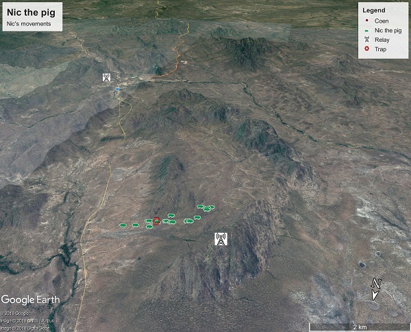
The team are following the movements of Nic the pig, the first feral animal collared with the tracking technology near Coen, Cape York. This Google Earth image shows where Nic travelled in early April 2018.
The data collected by this system will feed into a model that is able to ‘learn’ the behaviour of the animals over time.
Using machine learning, the data will help predict the animals’ future behaviour by measuring the temperature and humidity of different parts of the landscape against their movements.
Understanding where feral animals go under specific weather conditions will help to better manage their impacts.
Working with environmental managers, like the Indigenous ranger groups, is also ensuring that the new tracking system is co-designed by the people who will use them.
This means the technology and insights it delivers will be available sooner in the areas where it is most needed, offering the potential to change long-term management strategies.
